
Altimeter Mountain GPS Tracker
Reklamalar mavjud
4,5star
593 ta sharh
100 ming+
Yuklanmalar

3+
info


Bu ilova haqida
Turn your smartphone into a multi-functioned altimeter. Our unique algorithms determine your elevation using three sources - the GPS system in your phone, network services, and when available, your device’s barometer. Our algorithm combines data from all three sources to give you the most accurate reading possible.
🏔️ High-Precision Altitude Tracking: Experience unparalleled elevation accuracy with our unique algorithm that synergizes GPS, network services, and barometric data.
🌍 Real-Time Location & Coordinates: Stay informed with instant access to your current location and precise coordinates, wherever your adventure takes you.
🌬️ Barometric Pressure at Your Fingertips: Monitor the current barometric pressure seamlessly, ensuring you're always prepared for changing weather conditions.
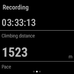
📊 Advanced Trip Data Measurement: Track your journey with detailed trip data, capturing every step of your adventure.
🗺️ Dynamic Route Mapping: See your trail come to life on a map, with your route vividly drawn and easy to follow.
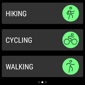
🚴 Customizable Activity Types: Tailor your tracking whether you're hiking, cycling, or embarking on other exciting activities.
📈 Comprehensive Trip Analytics: Delve into various trip data like uphill distance, elevation gain, pace, and calories burned for a thorough overview.
📉 Insightful Charts and Graphs: Visualize your performance with charts showing elevation over distance, speed over time, and more.
🆘 SOS Rescue Message Feature: Stay safe with the SOS feature, providing peace of mind during solo or remote adventures.
📸 Trip Photography with Data Overlay: Capture memorable moments with photos featuring overlaid trip data, pinned exactly where you took them.
📍 Map Waypoints with Essential Info: Mark and remember key locations with detailed waypoints on your map.
🕒 Access Historical Trip Data: Reflect on your past adventures with easy access to your historical trip data.
🔄 Flexible Data Export and Import: Export your trips to GPX, KML, KMZ formats, and import GPX data for enhanced tracking.
🗾 Offline Map Downloads: Never lose your way with offline maps, perfect for areas with no internet connectivity.
⬆️⬇️ Detailed Uphill and Downhill Data: Gain insights into every segment of your journey, with specific uphill and downhill data.
🔗 Sync and Web Panel Access: Log in to synchronize your data and view it conveniently on a web panel.
🔉 Motivating Audio Cues: Receive audio updates at specific time intervals or distances traveled, keeping you motivated and informed.
⌚ Wear OS Compatibility: Enjoy the freedom of tracking your trips with the convenient Wear OS app.
🏔️ Strava account integration. Easy send your trip to Strava.
Know your exact heading on your current route, view your current position on the map and use the app to track any route you choose. The app tracks, follows and displays your route in real time, displays it and then draws elevation and speed charts during your trip. Kick back in your favorite chair after a long trip and view all of the adventures you’ve been on, our app automatically saves all of them in our database.
Tap or move your finger on or over any value on the chart to know when and where a particular value occurred. You can also choose from multiple functions such as speedometer, calorie counter, checkpoint times, notification sounds at preset milestones, and even auto pause should you decide to stop somewhere for coffee or to take a photo. If you do stop to take photos, they can easily be added with the data of your current position overplayed right on top. Your photos will have elevation, average speed, location info right on them.
If you want to see your route in maps or another application you can easily export track data to following formats:
- GPX
- KML
- KMZ
Terms and conditions: https://mysticmobileapps.com/legal/terms/altimeter.html
Privacy policy: https://mysticmobileapps.com/legal/privacy/altimeter.html
🏔️ High-Precision Altitude Tracking: Experience unparalleled elevation accuracy with our unique algorithm that synergizes GPS, network services, and barometric data.
🌍 Real-Time Location & Coordinates: Stay informed with instant access to your current location and precise coordinates, wherever your adventure takes you.
🌬️ Barometric Pressure at Your Fingertips: Monitor the current barometric pressure seamlessly, ensuring you're always prepared for changing weather conditions.
📊 Advanced Trip Data Measurement: Track your journey with detailed trip data, capturing every step of your adventure.
🗺️ Dynamic Route Mapping: See your trail come to life on a map, with your route vividly drawn and easy to follow.
🚴 Customizable Activity Types: Tailor your tracking whether you're hiking, cycling, or embarking on other exciting activities.
📈 Comprehensive Trip Analytics: Delve into various trip data like uphill distance, elevation gain, pace, and calories burned for a thorough overview.
📉 Insightful Charts and Graphs: Visualize your performance with charts showing elevation over distance, speed over time, and more.
🆘 SOS Rescue Message Feature: Stay safe with the SOS feature, providing peace of mind during solo or remote adventures.
📸 Trip Photography with Data Overlay: Capture memorable moments with photos featuring overlaid trip data, pinned exactly where you took them.
📍 Map Waypoints with Essential Info: Mark and remember key locations with detailed waypoints on your map.
🕒 Access Historical Trip Data: Reflect on your past adventures with easy access to your historical trip data.
🔄 Flexible Data Export and Import: Export your trips to GPX, KML, KMZ formats, and import GPX data for enhanced tracking.
🗾 Offline Map Downloads: Never lose your way with offline maps, perfect for areas with no internet connectivity.
⬆️⬇️ Detailed Uphill and Downhill Data: Gain insights into every segment of your journey, with specific uphill and downhill data.
🔗 Sync and Web Panel Access: Log in to synchronize your data and view it conveniently on a web panel.
🔉 Motivating Audio Cues: Receive audio updates at specific time intervals or distances traveled, keeping you motivated and informed.
⌚ Wear OS Compatibility: Enjoy the freedom of tracking your trips with the convenient Wear OS app.
🏔️ Strava account integration. Easy send your trip to Strava.
Know your exact heading on your current route, view your current position on the map and use the app to track any route you choose. The app tracks, follows and displays your route in real time, displays it and then draws elevation and speed charts during your trip. Kick back in your favorite chair after a long trip and view all of the adventures you’ve been on, our app automatically saves all of them in our database.
Tap or move your finger on or over any value on the chart to know when and where a particular value occurred. You can also choose from multiple functions such as speedometer, calorie counter, checkpoint times, notification sounds at preset milestones, and even auto pause should you decide to stop somewhere for coffee or to take a photo. If you do stop to take photos, they can easily be added with the data of your current position overplayed right on top. Your photos will have elevation, average speed, location info right on them.
If you want to see your route in maps or another application you can easily export track data to following formats:
- GPX
- KML
- KMZ
Terms and conditions: https://mysticmobileapps.com/legal/terms/altimeter.html
Privacy policy: https://mysticmobileapps.com/legal/privacy/altimeter.html
Oxirgi yangilanish
Xavfsizlik — dastur ishlab chiquvchilar maʼlumotlaringizni qanday jamlashi va ulashishini tushunishdan boshlanadi. Maʼlumotlar maxfiyligi va xavfsizlik amaliyotlari ilovadan foydalanish, hudud va yoshga qarab farq qilishi mumkin. Bu axborot dastur ishlab chiquvchi tomonidan taqdim etilgan va keyinchalik yangilanishi mumkin.

Bu ilova tashqi hamkorlarga quyidagi turdagi maʼlumotlarini ulashishi mumkin
Ilova tarixi, Ilova axboroti va unumdorlik va Qurilma yoki boshqa identifikatorlar

Ushbu ilova quyidagi axborot turlarini toʻplashi mumkin
Joylashuv, Ilova tarixi va yana 2 ta

Maʼlumotlar uzatish vaqtida shifrlanadi

Maʼlumotlarni oʻchirishni soʻrashingiz mumkin
Reytinglar va sharhlar
4,6
518 ta sharh

Sanjar Bashirov
- Nomaqbul deb belgilash
14-aprel, 2022
Bu ilova qanday ishlaydi, tekislikdan tepalikni balandligini qanday qilib oʻlchash mumkin.
Nima yangiliklar
- Minor bug fixes
Ilova yuzasidan yordam
Dasturchi haqida
MYSTIC MOBILE APPS LLC
support@mysticmobileapps.com
8 The Grn Ste B
Dover, DE 19901
United States
+1 815-324-0550


